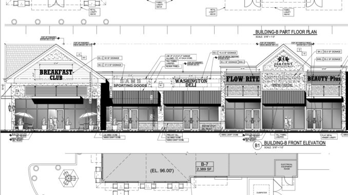
TOWNSHIP OF WASHINGTON—The applicant pursuing a 17,100-square-foot strip mall in place of five single-family homes at Pascack Road and Washington Avenue has signed off on a postponement of a sixth hearing.
Originally set for March 21, the Zoning Board of Adjustment’s next hearing on the matter is April 18. The ZBA is still meeting March 21, on other business.
The hearing is anticipated to offer testimony from the township’s engineer, Boswell Engineering, on an independent review of applicant 660 Pascack Realty LLC’s traffic study, prepared by Dean & Dolan of Somerville.
The study found an increase of 43 vehicles amid peak travel, which was deemed “inconsequential” to overall traffic volume, given ongoing improvements to the well-traveled intersection of two county roads.
Generally, such reports are made public at least 10 days in advance of a public hearing. As of our press deadline, no report appeared to have been released.
ZBA officials said applicant attorney Bruce Whitaker had sent a letter agreeing to allow the board until April 19 to make a decision on the application. Due to time constraints for making a decision, the applicant attorney must approve extensions of the hearing process.
We requested the applicant attorney’s meeting delay request letter and information on the Boswell Engineering traffic study in discussion.
Meanwhile, Meisten Street and Burke Street neighbors, pressed the Township Council March 20 to take action on determining once and for all whether the unnamed tributary behind the proposed mall is a protected Category One waterway.
In addition, the council approved township attorney Kenneth Poller to conduct a title search of Michael Agnello’s property, at 667 Meisten St., to determine whether an easement for the unnamed tributary existed.
Agnello claims the easement was there when he bought the property more than four decades ago and that he was always told the stream was a protected C1 waterway.
Township officials are awaiting a proposal from Boswell Engineering to determine whether the drainage basin is more or less than 50 acres, including a review of LIDAR data maps prepared by Najarian Associates for Bertin Engineering, the engineer on 660 Pascack Realty LLC’s Four Seasons Marketplace proposal.
LIDAR stands for “light detection and ranging,” a remote sensing method that uses light in the form of pulsed laser to measure ranges, or variable distances, to the earth. These light pulses, combined with other data recorded by an airborne system (drone; plane; helicopter) generates precise 3-dimensional information about the shape of the earth and its surface characteristics, according to the National Oceanic and Atmospheric Administration.
(See “Do mall applicant’s drainage basin calculations hold water?”, Michael Olohan, March 13, 2023.)
Under the bills list approved in council March 20, three line items were listed for Boswell Engineering as “Proposal For Musquapsink Brook” and totaled $5,881.25. They were not discussed publicly by the council. The three items were listed as costing $2,176, 1,158.50, and $2,546.75.
Standards questioned
Meanwhile, Emerson resident and professional engineer Carol Hoernlein, writing as an interested outside observer, told Pascack Press recently that the LIDAR data being used was not “the standard” for determining a drainage basin’s size. (“Questioning developer on standards,” Letters, page 21, March 20, 2023.)
Instead, she wrote, the U.S. Geologic Service (USGS) Streamstats was the standard measuring tool used by NJDEP. It “is more accurate than town tax maps or FEMA Firm maps because it delineates drainage areas, not just flood areas. Streamstats is easily available to anyone through the USGS website and takes minutes to use.”
She added, “I am concerned the USGS standard is not being used here. The borough engineer is raising questions of the developer’s engineer regarding the use of a different technique to calculate drainage area. I would be too. It may seem simple, but the answer is the difference between NJDEP protection of a ‘regulated water,’ beloved local lake and our drinking water (Oradell) reservoir, or no protection at all.”
The applicant’s Flood Hazard Area Determination letter, dated Jan. 30, 2020, from NJDEP’s Bureau of Inland Regulation, states that “a Flood Hazard Area Permit is not required” for the unnamed tributary as its drainage area is less than 50 acres (48.2 acres), which “was confirmed with Najarian Associates using LIDAR data and a field investigation. The water feature does not have a riparian zone associated with it,” concludes the NJDEP.
