
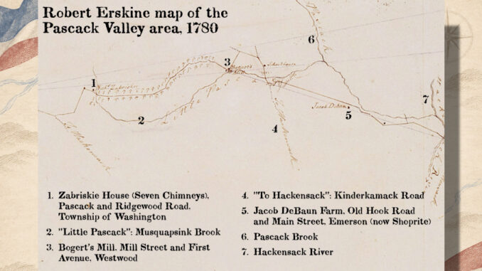
PASCACK VALLEY—Where Emerson shoppers now turn in for groceries at Old Hook Road and Main Street, George Washington’s mapmaker marked Jacob DeBaun’s farm. A little farther along on Robert Erskine’s 1780 map of the Pascack Valley is Bogert’s Mill, at a spot Westwood residents can still find by its street names alone: Mill Street and First Avenue.
Historian William “Billy” Neumann will tell the story of the man behind that map on Sunday, Nov. 15, at 2 p.m., when the Pascack Historical Society presents “Robert Erskine: Mapmaker to George Washington” at its museum, 19 Ridge Ave.
Erskine was a Scottish-born engineer running the ironworks at Ringwood when Washington chose him in 1777 to serve as the Continental Army’s first geographer and surveyor general.
Before Washington could move troops through unfamiliar country, he needed to know where the roads led and what his men would encounter along the way.
Getting those details onto paper took time. In a letter to Washington, Erskine estimated that a surveyor with a crew of six could cover about five miles a day. Two people would carry the measuring chain, one the instrument and three the flagstaffs used to sight a straight line. Princeton University Library’s account of Erskine’s survey work
Nearly 250 years later, valley residents can follow some of those lines through their own neighborhoods. The road marked “To Hackensack” is Kinderkamack Road. The stream identified as “Little Pascack” is Musquapsink Brook. And near the meeting of Pascack and Ridgewood roads in the Township of Washington, the map marks the Zabriskie house, known locally as Seven Chimneys.
The museum opens at 1 p.m., an hour before the talk. Admission is free for Pascack Historical Society members and $10 at the door for nonmembers. Light refreshments will be served. Seating is limited and first come, first served.