

RIVER VALE, N.J.—Hoping to get an accurate count of deer population “calling” River Vale home, Township Council members approved an aerial deer survey April 22 that will provide a local census to help determine how many deer should be killed during a planned bowhunt later this year.
Several council members had called for a local deer census prior to conducting a deer bow hunt, which council approved unanimously April 8.
Councilmembers cited a spike in deer–auto vehicle incidents, spread of Lyme disease, and destruction of landscaping and plants—along with the risk of a human fatality caused by a deer-vehicle collision—as top reasons for approving a deer hunt.
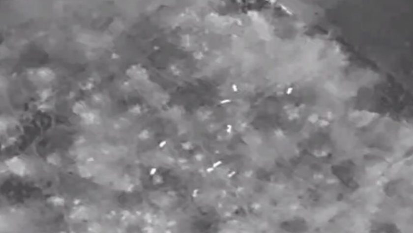
Voting 4–0, council members approved a $3,367 contract to conduct a deer population survey using drones fitted with infrared cameras, according to the resolution. Councilman John Donovan was absent.
The contract was awarded to Jay F. Kelly, a biology professor at Raritan Valley Community College, Branchburg, who has experience conducting such wildlife surveys.
Council President Mark Bromberg said Mayor Glen Jasionowski has been communicating with state Division of FIsh and Wildlife officials since council voted to move ahead with a bowhunt to cull local deer numbers. Jasionowski did not attend Monday’s meeting.
Both Bromberg and council Vice President Paul Criscuolo said the results of the deer survey were unlikely to affect the decision to hold a hunt, unless deer population numbers came back near zero, which was not anticipated.
Township Administrator Gennarro Rotella said the drone survey takes about three days, and must be done now before the trees bloom to get an accurate count.
Bromberg said the deer census would help DEP Fish and Wildlife to determine the number of deer to be culled to bring the population back into balance.
Rotella said the state Fish and Wildlife officials will “clearly define how and where we move forward” when a resident asked if local bowhunters could participate in the hunt.
Hunt ‘very controlled’
Bromberg said he did not believe local bowhunters would be allowed, noting the hunt “is a very controlled and restricted operation.”
Previously, Jasionowski said the township would consult with state Fish and Wildlife on the hunt and that a professional bowhunting group certified by state DEP would likely be contracted.
He said then no residents’ private properties would be used for the hunt and that it would likely occur only on two public golf courses or other public space.
“My administration recommends a controlled hunt on our golf courses and on appropriate nonresidential open spaces,” Jasionowski had said after the council reached a consensus April 8.
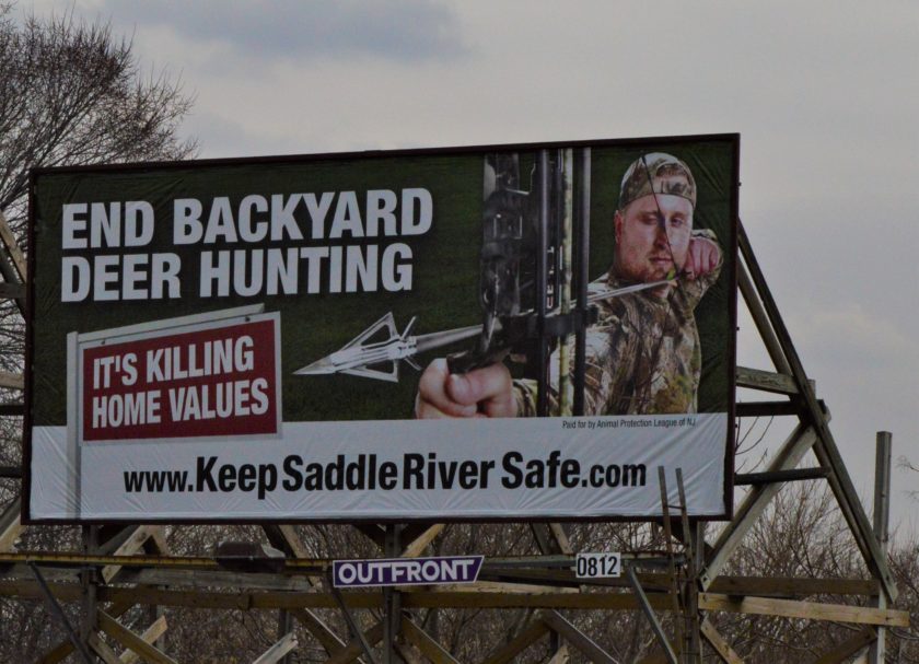
Only one municipality in Bergen County, Saddle River, has conducted a regulated bow hunt during the 2018-2019 season, which killed 135 deer.
Saddle River officials declared the hunt a success though it was unclear if the deer culled met DEP’s herd reduction goals.
During Monday’s meeting, animal-protection advocate Mark Nagelhout of Park Ridge, a member of Animal Protection League of New Jersey, said that a so-called controlled hunt was not possible using bow hunters.
He said Saddle River’s bow hunt experience showed wounded deer running onto other residents’ properties, running onto roadways, and being “impaled on fences.”
Drone counts ‘very accurate’
Reached April 23, Kelly said the drone survey began an hour before sunset April 22 and was expected to be completed in several days.
He said deer census results are generally valid for a year.
“The numbers we obtain at this time of year are the most conservative, after hunting and before birthing. With simple calculations we can estimate the total population for the remainder of the year based on average birth rates, survival, etc. until the hunting season and winter mortality sets in again,” emailed Kelly to Pascack Press.
He said drone surveys of deer using infrared camera “are very accurate if conducted properly with a trained pilot with necessary biological knowledge needed to interpret the data.”
He said drone surveys have “a distinct advantage” over road-based “spotlight surveys” that are limited to only counting deer visible from the road.
Also, he said drone surveys have an advantage over aerial surveys conducted by conventional aircraft as “they can hover over objects of interest and investigate from different angles and over time, which can help differentiate deer from other species or objects that might be mistaken for a deer,” he said.
Kelly noted the deer survey goal “is to cover all parts of town, plus an additional buffer area around the periphery since deer populations do not abide by political boundaries.”