

TOWNSHIP OF WASHINGTON—A Meisten Street resident speaking out against the way a proposed strip mall is eyed for his neighborhood — and adjacent to the busy Pascack Road—Washington Avenue intersection — says he hopes to get a survey and title search done soon on his property.
His task: to prove that an easement has long existed and that a modest waterway coursing through his property has been and should be a protected Category 1 stream, regulated under NJDEP rules.
If the waterway is not protected, resident Michael Agnello says he fears that more runoff from the proposed 17,100-square foot retail plaza, 4 Seasons Marketplace, might further degrade water quality, increase flooding, and impair a waterway that feeds into Oradell Reservoir.
That reservoir is owned by Veolia North America and provides drinking water to 800,000 Bergen County residents.
The project site’s three long-vacant and deteriorating homes along Pascack Road — opposite Seasons Catering — are owned by James “Jimmy” Kourgelis, a Seasons Catering owner, as are the other two homes comprising the 660–682 Pascack Road tract proposed for a strip mall.
The matter is before the Zoning Board of Adjustment, where the applicant seeks a use variance to operate the mall in a residential zone.
The applicant initially proposed, in 2020, a commuter parking lot on the site, not a strip mall, and won assurance that it did not therefore need a flood hazard area permit. The project, Agnello says, has changed, and therefore so should the threshold for permitting.
Meanwhile, the applicant has declined our interview requests, saying it will speak only through professionals in public proceedings. The ZBA next meets Tuesday, Feb. 28 at 7:30 p.m. in person at Council Chambers and on Zoom.
Getting the facts to flow
In less than a decade, a small waterway behind some homes that enters Musquapsink Brook, heads to Schlegel Lake, and then heads toward Pascack Brook — which drains into Oradell Reservoir — went from a protected waterway to a non-protected waterway.
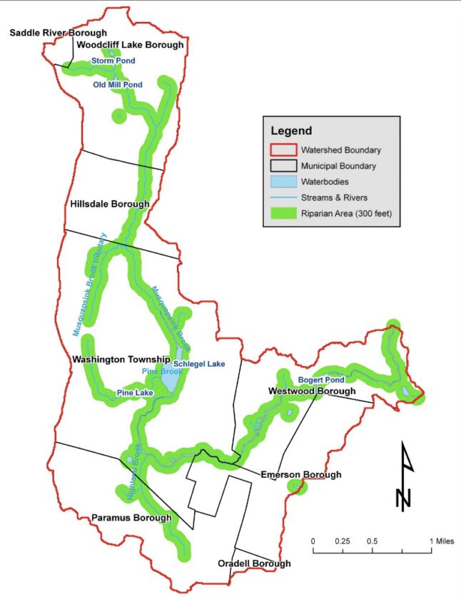
The difference, says Agnello, was a Jan. 30, 2020 letter from NJDEP’s Division of Land Use Regulation that declares the stream behind the five lots proposed for the mall as only draining a 48.2-acre basin while just seven years before the same stream drained an area over 50 acres, which qualified it as a regulated stream and likely protection under state “Category One” or C1 water quality rules.
C1 waterways are state-protected waterways buffered by riparian zones and regulated to prevent land uses that may impair water quality, says NJDEP.
The unnamed tributary to Musquapsink Brook eventually feeds into Pascack Brook that goes toward Oradell Reservoir. Its use as a water supply waterway designates it as a C1 stream, says NJDEP.
On Feb. 15, Lawrence Hajna, an NJDEP spokesman, directed Pascack Press to an NJDEP website on C1 waterways in New Jersey. The only reference to the area is:
“Pascack Brook (Hackensack) — New York/New Jersey State line to confluence with the Oradell Reservoir, including Woodcliff Lake, and all tributaries FW2-NT (C1).” That reference indicates the small tributary likely is a Category One waterway.
Agnello wonders how a stream previously regulated as a C1 waterway is no longer a protected stream. He said he has ordered a survey of his property and a title search to determine whether a stream easement existed on his property.
He said for 40-plus years he was told by town officials he had to consult with NJDEP over any land alterations or uses near the stream.
Agnello also said he met recently on his property with township administrator Mark DiCarlo and Boswell Engineer John Yakimic, and Burke Street neighbor James Walsh to go over some maps and documents that he said raised questions about the engineering studies that determined the drainage basin totaling only 48.2 acres.
He said local officials said they would let him know what they found out, adding he sensed the engineer felt something was awry.
At the Feb. 21 council meeting, DiCarlo told Agnello that it was best if he made his case to the Zoning Board of Adjustment.
DiCarlo agreed that NJDEP makes the final decision on a C1 waterway and said he sent a public records request to DEP to “find a better trail of paperwork as to initiation and declassification of the C1 waterway.”
DiCarlo also said he would have Boswell do a title search of Agnello’s property for a stream easement if his surveyor had not already undertaken such a search.
Agnello urged the Township Council on Feb. 21 to support the residents of Meisten Street, Burke Street, Northgate condos and Jacquelin Woods to keep the stream’s C1 water designation. He urged them to help protect the waterway but officials did not agree to provide support.
DiCarlo told Agnello that Zoning Board Chair Michael DeSena was made aware that 660 Pascack Realty LLC’s initial application was for a parking lot and not a strip mall.
Agnello said the applicant proposing a 17,100-square-foot strip mall on the five lots near Pascack–Washington, three with vacant, boarded up houses and two currently occupied at 660-682 Pascack Road, initially submitted drainage and elevation maps to NJDEP for permission to construct a 137-space commuter parking lot over four lots, which also included parking for Seasons Catering.
(That was years prior to current construction on a commuter lot next to the new Emergency Services Building.)
In two documents filed by applicant 660 Pascack Realty LLC for a Flood Hazard Area Determination to construct a 137-space parking lot, the waterway in Agnello’s backyard is called an “unnamed tributary” and an “unnamed ditch.”
660 Pascack Realty’s approval to build the parking lot was granted in the Jan. 30, 2020 letter, which found that a “Flood Hazard Area permit is not required.”
However, the applicant did not build a commuter parking lot on the site. Now the applicant plans to build a 17,100-square-foot strip mall, Agnello said, instead of a commuter parking lot.
The Jan. 30, 2020 NJDEP letter further states the reason for the decision was: “The stream has a drainage area of less than 50 (48.2 acres). This was confirmed with Najarian Associates using LIDAR data and a field investigation. The water feature does not have a riparian zone associated with it,” states the NJDEP Flood Hazard Area Determination letter sent to Calisto Bertin, applicant engineer for 660 Pascack Realty LLC’s proposal for “4 Season Marketplace” mall now before the Zoning Board of Adjustment.
Almost a year before (Jan. 22, 2019) the NJDEP determined a Flood Hazard Area permit was not needed for a 137-space parking lot near the stream, NJDEP environmental specialist Monica Zabroski wrote an email stating that 660 Pascack Realty LLC “will need to document a compelling public need for the parking lot and demonstrate that this location within the riparian zone is the only practicable location (i.e. no other available areas outside of the regulated areas.)”
Zabroski noted further, “Any riparian zone disturbance must be minimized, and located as far from the stream as feasible. If it is documented that this location is the only practicable location, then the number of parking spaces should be greatly reduced and the applicant will need to provide documentation demonstrating the need for the minimal number of spaces.”
Efforts to determine how the regulated stream, with riparian buffer requirements as noted by NJDEP, became no longer regulated, could not be determined. Requests to NJDEP for comment did not clarify why the stream no longer qualified under Category One waters.
Previous 2012 NJDEP Ruling on Tributary
Moreover, Agnello told the Township Council that he discovered an April 13, 2012 letter from NJDEP Division of Land Use Regulation to former Township Engineer Chris Statile that stated that the stream, an unnamed tributary of the Musquapsink Brook, has a drainage area greater than 50 acres.
“After a review of the submitted drainage area maps it was determined the stream has a drainage area greater than 50 acres. A Flood Hazard Area verification is required to establish the flood hazard elevation and riparian zone limits. The previously issued Flood Hazard Area verification letter, dated Feb. 25, 2009, is now considered null and void,” states the April 2012 Flood Hazard Area Determination letter.
The NJDEP letter further notes, “Comparing the submitted drainage area maps with Lapatka Associates drainage area map, inlets are shown in the vicinity of Hillsdale Avenue and Ellen Court which pick up additional drainage not shown on the Lapatka drainage area map.”
Pascack Press reached out to Statile for comment but did not hear back by press time.
Talking with Pascack Press, Agnello said the stream enters the Musquapsink, then Schlegel Lake, Pascack Brook and Oradell Reservoir. According to NJDEP, waterways that supply drinking water reservoirs are considered Category One, and require protection.
The lay of the land
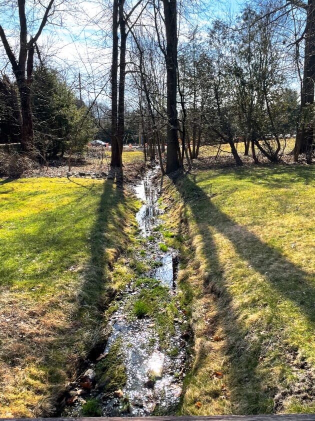
When a reporter visited him on Feb. 20, the small stream in his backyard was flowing steadily, and stream banks appeared to be eroded from prior storms. Large areas of the stream bed appeared clogged with sediment, and grass grew on parts of it.
He pointed out that during new construction on the Pascack-Washington intersection, Bergen County had placed a concrete culvert under Washington Avenue to help with storm flows.
Behind some large shrubs, and a 4-foot-high retaining wall, a reporter could glimpse the three vacant homes from his backyard.. Agnello said James Kourgelis had put up the retaining wall and shrubs as a favor to help shield the view of the vacant properties from his home.
Another nearby neighbor, James Walsh, Burke Street, told Pascack Press recently that areas in nearby Northgate Condominium complex that once included a small stream, now redirected into a detention basin, flow steadily and sometimes heavily during rain storms through his backyard.
He said that the Northgate drainage area was not included in the maps submitted by the applicant for NJDEP Flood Hazard Area approval. He said areas not included could easily push the drainage basin over the 50 acres threshold required to be regulated by NJDEP permit.
He showed us a depressed, low area of his yard where water runs, and sometimes pools, following a heavy rain. He said that storm runoff drains to the unnamed tributary behind Agnello’s house. Walsh said he hoped to present testimony that a large area was left out of the applicant’s drainage maps at a Zoning Board hearing.
Rutgers report: Brook, tribs lead to Oradell Reservoir
In a 2012 Rutgers University Cooperative Extension Water Resources Program report. Musquapsink Brook Watershed Restoration and Protection Plan, the report notes the importance of the Musquapsink Brook to the area’s water supply.
The Musquapsink Brook is a tributary of the Pascack Brook, which flows along the New York/New Jersey State line to its confluence with the Oradell Reservoir. The Reservoir is managed by United Water of New Jersey and provides drinking water for an estimated 800,000 residents of Bergen and Hudson counties (United Water, 2010).
The Pascack Brook and its tributaries are classified as FW2-NT (C1), or freshwater (FW) non-trout (NT) category one (C1) in the 2010 N.J.A.C. 7:9B New Jersey Surface Water Quality Criteria. “FW2” refers to water bodies that are used for primary and secondary contact recreation; industrial and agricultural water supply; maintenance, migration, and propagation of natural and established biota; public potable water supply after conventional filtration treatment and disinfection; and any other reasonable uses, states the Rutgers study.
NT means those freshwaters that have not been designated as trout production or trout maintenance. NT waters are not suitable for trout due to physical, chemical, or biological characteristics, but can support other fish species.
C1 refers to those waters designated “for protection from measurable changes in water quality based on exceptional ecological significance, exceptional recreational significance, exceptional water supply significance or exceptional fisheries resource(s) to protect their aesthetic value (color, clarity, scenic setting) and ecological integrity (habitat, water quality and biological functions) (NJDEP, 2011).”
The C1 classification for the Musquapsink Brook and Pascack Brook are due to their significance as sources for the Oradell Reservoir, notes the report.
The report notes that having more riparian zones, or transition areas between pervious surfaces and the stream, would improve Musquapsink water quality.
“Riparian zones are important natural filters of stormwater runoff, protecting aquatic environments from excessive sedimentation, pollutants, and erosion. They supply shelter and food for many aquatic animals and also provide shade, an important part of stream temperature regulation. Because the streams within the Musquapsink Brook Watershed are designated as “C1,” New Jersey regulations require a 300 foot buffer on either side of the waterway (NJDEP, 2011),” states the 2012 Rutgers study.
“Approximately 1,444 acres of land are designated as riparian area in the Musquapsink Brook Watershed using the 300 foot buffer rule (Figure 7). Riparian zones are instrumental in water quality improvement for both surface runoff and water flowing into streams through subsurface or groundwater flow.
“The decrease of riparian areas in the Musquapsink Brook Watershed due to urbanization has contributed to poor surface water quality conditions and increased streambank erosion,” the report adds.
From the figure 7 map, it appears the stream abutting Agnello’s property should require a riparian zone. However, many such protective zones were neither enforced nor required.
The study lists recommendations to improve Musquapsink Brook water quality, including eight site-specific restoration projects in the township.
One local recommendation includes Washington Town Center: “This site is occupied by a shopping center. The parking lot of the shopping center is in close proximity to the Musquapsink Brook; they are separated by just a small grassed area. There is evidence of streambank erosion, and the site would benefit from streambank stabilization measures. A rain garden or swale can be installed to capture the pollutants in runoff from the nearby parking lot.
“In addition, the parking lot can be retrofitted with permeable pavement,” states the report.
We are working to determine if any restoration projects recommended in the 2012 Rutgers study were completed.
Applications on the ZBA’s agenda at press time (see website for details)
- 396 Jackson Ave. — Feb. 27, 2023 at 7:30 p.m.
- 174 Lafayette Ave. — Feb. 27, 2023 at 7:30 p.m.
- 4 Seasons Town Square — Feb. 28, 2023 at 7:30 p.m.
- 11 Blvd. S. — to be continued March 21, 2023 at 7:30 p.m.